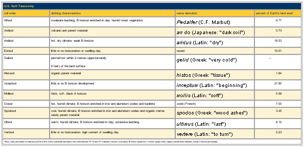
SOIL TAXONOMY (U.S.D.A.) — SOIL TAXONOMY u.s.d.a. La «Soil Taxonomy» du ministère de l’Agriculture des États Unis (Agric. hand b., 436, Washington, 1975) est, comme son nom l’indique, une taxonomie pédologique dont les ordres, rangés alphabétiquement, comportent dix… … Encyclopédie Universelle
Soil Taxonomy — La taxonomía de suelos de USDA, (Soil Taxonomy, en inglés), fue desarrollada y coordinada internacionalmente por el Ministerio de Agricultura de los Estados Unidos (USDA, acrónimo (en inglés) para el United States Department of Agriculture y su… … Wikipedia Español
1938 USDA soil taxonomy — The 1938 USDA soil taxonomy was a soil classification system adopted by the United States Department of Agriculture, now obsolete. The classification system used previously was developed and published in 1936 by C.F. Marbut, who was chief of the… … Wikipedia
Soil Taxonomy — Als USDA Bodenklassifikation bezeichnet man eine Klassifikation von Böden, die das amerikanische Landwirtschaftsministerium (US Department of Agriculture, USDA Natural Resources Conservation Service, NRCS) herausgegeben hat. Sie stellt neben der… … Deutsch Wikipedia
USDA soil taxonomy — developed by United States Department of Agriculture and the National Cooperative Soil Survey provides an elaborate classification of soil types according to several parameters (most commonly their properties) and in several levels: Order ,… … Wikipedia
Soil classification — deals with the systematic categorization of soils based on distinguishing characteristics as well as criteria that dictate choices in use. Overview Soil classification is a dynamic subject, from the structure of the system itself, to the… … Wikipedia
Soil science — is the study of soil as a natural resource on the surface of the earth including soil formation, classification and mapping; physical, chemical, biological, and fertility properties of soils; and these properties in relation to the use and… … Wikipedia
Soil horizon — Soil samples illustrating horizons (subsoil on right) A soil horizon is a specific layer in the land area that is parallel to the soil surface and possesses physical characteristics which differ from the layers above and beneath … Wikipedia
Soil survey — Soil survey, or soil mapping, is the process of classifying soil types and other soil properties in a given area and geo encoding such information. It applies the principles of soil science, and draws heavily from geomorphology, theories of soil… … Wikipedia
soil — soil1 soilless, adj. /soyl/, n. 1. the portion of the earth s surface consisting of disintegrated rock and humus. 2. a particular kind of earth: sandy soil. 3. the ground as producing vegetation or as cultivated for its crops: fertile soil. 4. a… … Universalium

