- Mauritania
-
—Mauritanian, adj., n./mawr'i tay"nee euh/, n.1. Official name, Islamic Republic of Mauritania. a republic in W Africa, largely in the Sahara Desert: formerly a French colony; a member of the French Community 1958-66; independent 1960. 2,411,317; 418,120 sq. mi. (1,082,931 sq. km). Cap.: Nouakchott.2. Mauretania.
* * *
Mauritania
Introduction Mauritania -
Background: Independent from France in 1960, Mauritania annexed the southern third of the former Spanish Sahara (now Western Sahara) in 1976, but relinquished it after three years of raids by the Polisario guerrilla front seeking independence for the territory. Opposition parties were legalized and a new constitution approved in 1991. Two multiparty presidential elections since then were widely seen as flawed, but October 2001 legislative and municipal elections were generally free and open. Mauritania remains, in reality, a one-party state. The country continues to experience ethnic tensions between its black minority population and the dominant Maur (Arab-Berber) populace. Geography Mauritania
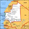
Location: Northern Africa, bordering the North Atlantic Ocean, between Senegal and Western Sahara
Geographic coordinates: 20 00 N, 12 00 W
Map references: Africa
Area: total: 1,030,700 sq km land: 1,030,400 sq km water: 300 sq km
Area - comparative: slightly larger than three times the size of New Mexico
Land boundaries: total: 5,074 km border countries: Algeria 463 km, Mali 2,237 km, Senegal 813 km, Western Sahara 1,561 km
Coastline: 754 km
Maritime claims: contiguous zone: 24 NM territorial sea: 12 NM continental shelf: 200 NM or to the edge of the continental margin exclusive economic zone: 200 NM
Climate: desert; constantly hot, dry, dusty
Terrain: mostly barren, flat plains of the Sahara; some central hills
Elevation extremes: lowest point: Sebkha de Ndrhamcha - 3 m highest point: Kediet Ijill 910 m
Natural resources: iron ore, gypsum, copper, phosphate, diamonds, gold, oil; fish
Land use: arable land: 0.48% permanent crops: 0.01% other: 99.51% (1998 est.)
Irrigated land: 490 sq km (1998 est.)
Natural hazards: hot, dry, dust/sand-laden sirocco wind blows primarily in March and April; periodic droughts Environment - current issues: overgrazing, deforestation, and soil erosion aggravated by drought are contributing to desertification; very limited natural fresh water resources away from the Senegal which is the only perennial river Environment - international party to: Biodiversity, Climate
agreements: Change, Desertification, Endangered Species, Hazardous Wastes, Law of the Sea, Nuclear Test Ban, Ozone Layer Protection, Ship Pollution, Wetlands signed, but not ratified: none of the selected agreements
Geography - note: most of the population concentrated in the cities of Nouakchott and Nouadhibou and along the Senegal River in the southern part of the country People Mauritania -
Population: 2,828,858 (July 2002 est.)
Age structure: 0-14 years: 46.1% (male 653,005; female 650,530) 15-64 years: 51.7% (male 720,473; female 741,094) 65 years and over: 2.2% (male 26,251; female 37,505) (2002 est.)
Population growth rate: 2.92% (2002 est.)
Birth rate: 42.54 births/1,000 population (2002 est.)
Death rate: 13.34 deaths/1,000 population (2002 est.)
Net migration rate: 0 migrant(s)/1,000 population (2002 est.)
Sex ratio: at birth: 1.03 male(s)/female under 15 years: 1 male(s)/female 15-64 years: 0.97 male(s)/female 65 years and over: 0.7 male(s)/ female total population: 0.98 male(s)/ female (2002 est.)
Infant mortality rate: 75.25 deaths/1,000 live births (2002 est.) Life expectancy at birth: total population: 51.53 years female: 53.71 years (2002 est.) male: 49.42 years
Total fertility rate: 6.15 children born/woman (2002 est.) HIV/AIDS - adult prevalence rate: 1.8% (2000 est.) HIV/AIDS - people living with HIV/ 6,600 (1999 est.)
AIDS:
HIV/AIDS - deaths: 610 (1999 est.)
Nationality: noun: Mauritanian(s) adjective: Mauritanian
Ethnic groups: mixed Maur/black 40%, Maur 30%, black 30%
Religions: Muslim 100%
Languages: Hassaniya Arabic (official), Pulaar, Soninke, Wolof (official), French
Literacy: definition: age 15 and over can read and write total population: 41.2% male: 51.5% female: 31.3% (2002 est.) Government Mauritania -
Country name: conventional long form: Islamic Republic of Mauritania conventional short form: Mauritania local short form: Muritaniyah local long form: Al Jumhuriyah al Islamiyah al Muritaniyah
Government type: republic
Capital: Nouakchott Administrative divisions: 12 regions (regions, singular - region) and 1 capital district*; Adrar, Assaba, Brakna, Dakhlet Nouadhibou, Gorgol, Guidimaka, Hodh Ech Chargui, Hodh El Gharbi, Inchiri, Nouakchott*, Tagant, Tiris Zemmour, Trarza
Independence: 28 November 1960 (from France)
National holiday: Independence Day, 28 November (1960)
Constitution: 12 July 1991
Legal system: a combination of Shari'a (Islamic law) and French civil law
Suffrage: 18 years of age; universal
Executive branch: chief of state: President Maaouya Ould Sid Ahmed TAYA (since 12 December 1984) head of government: Prime Minister Cheikh El Avia Ould Mohamed KHOUNA (since 17 November 1998) cabinet: Council of Ministers elections: president elected by popular vote for a six-year term; election last held 12 December 1997 (next to be held NA December 2003); prime minister appointed by the president election results: President Maaouya Ould Sid Ahmed TAYA reelected with 90.9% of the vote
Legislative branch: bicameral legislature consists of the Senate or Majlis al-Shuyukh (56 seats, a part of the seats up for election every two years; members elected by municipal leaders to serve six-year terms) and the National Assembly or Majlis al- Watani (81 seats; members elected by popular vote to serve five-year terms) elections: Senate - last held 17 April 1998 (next to be held NA April 2002); National Assembly - last held 19 and 26 October 2001 (next to be held NA 2006) election results: Senate - percent of vote by party - PRDS 98%, others 2%; seats by party - PRDS 56; National Assembly - percent of vote by party - PRDS 79%, RDU 3.5%, UDP 3.5%, AC 5%, RDF 4%, UFP 3.5%, FP 1.5%; seats by party - PRDS 64, UDP 3, RDU 3, AC 4, RDF 3, UFP 3,and FP 1
Judicial branch: Supreme Court or Cour Supreme; Court of Appeals; lower courts Political parties and leaders: Action for Change or AC [Messoud Ould BOULKHEIR]; Alliance for Justice and Democracy or AJD [Kebe ABDOULAYE]; Democratic and Social Republican Party or PRDS (ruling party) [President Maaouya Ould Sid Ahmed TAYA]; Mauritanian Party for Renewal and Concorde or PMRC [Molaye El Hassen Ould JIYID]; National Union for Democracy and Development or UNDD [Tidjane KOITA]; Party for Liberty, Equality and Justice or PLEJ [Daouda M'BAGNIGA]; Popular Front or FP [Ch'bih Ould CHEIKH MALAININE]; Popular Progress Alliance or APP [Mohamed El Hafed Ould ISMAEL]; Popular Social and Democratic Union or UPSD [Mohamed Mahmoud Ould MAH]; Progress Force Union or UFP [Mohamed Ould MAOULOUD]; Rally of Democratic Forces or RDF [Ahmed Ould DADDAH]; Rally for Democracy and Unity or RDU [Ahmed Ould SIDI BABA]; Union for Democracy and Progress or UDP [Naha Mint MOUKNASS] note: the Action for Change party was banned in January 2002; parties legalized by constitution ratified 12 July 1991, however, politics continue to be tribally based Political pressure groups and Arab nationalists; Ba'athists;
leaders: General Confederation of Mauritanian Workers or CGTM [Abdallahi Ould MOHAMED, secretary general]; Independent Confederation of Mauritanian Workers or CLTM [Samory Ould BEYE]; Islamists; Mauritanian Workers Union or UTM [Mohamed Ely Ould BRAHIM, secretary general] International organization ABEDA, ACCT, ACP, AfDB, AFESD, AL,
participation: AMF, AMU, CAEU, CCC, ECA, FAO, G-77, IBRD, ICAO, ICFTU, ICRM, IDA, IDB, IFAD, IFC, IFRCS, IHO (pending member), ILO, IMF, IMO, Interpol, IOC, ITU, NAM, OAU, OIC, OPCW, UN, UNCTAD, UNESCO, UNIDO, UPU, WCL, WHO, WIPO, WMO, WToO, WTrO Diplomatic representation in the US: chief of mission: Ambassador Mohamedou Ould MICHEL chancery: 2129 Leroy Place NW, Washington, DC 20008 FAX: [1] (202) 319-2623 telephone: [1] (202) 232-5700 Diplomatic representation from the chief of mission: Ambassador John W.
US: LIMBERT embassy: Rue Abdallaye, Nouakchott mailing address: BP 222, Nouakchott telephone: [222] 525-2660, 525-2663 FAX: [222] 525-1592
Flag description: green with a yellow five-pointed star above a yellow, horizontal crescent; the closed side of the crescent is down; the crescent, star, and color green are traditional symbols of Islam Economy Mauritania
Economy - overview: Half the population still depends on agriculture and livestock for a livelihood, even though most of the nomads and many subsistence farmers were forced into the cities by recurrent droughts in the 1970s and 1980s. Mauritania has extensive deposits of iron ore, which account for half of total exports. The decline in world demand for this ore, however, has led to cutbacks in production. The nation's coastal waters are among the richest fishing areas in the world, but overexploitation by foreigners threatens this key source of revenue. The country's first deepwater port opened near Nouakchott in 1986. In the past, drought and economic mismanagement resulted in a buildup of foreign debt. In February, 2000, Mauritania qualified for debt relief under the Heavily Indebted Poor Countries (HIPC) initiative and in December 2001 received strong support from donor and lending countries at a triennial Consultative Group review. Mauritania withdrew its membership in the Economic Community of West African States (ECOWAS) in 2000 and subsequently increased commercial ties with Arab Maghreb Union members Morocco and Tunisia, most notably in telecommunications. In 2001, exploratory oil wells in tracts 80 km offshore indicated potential viable extraction at current world oil prices. However, the refinery in Nouadhibou historically has not exceeded 20% of its distillation capacity, and it handled no crude in the year 2000. A new Investment Code approved in December 2001 improved the opportunities for direct foreign investment.
GDP: purchasing power parity - $5 billion (2001 est.)
GDP - real growth rate: 4% (2001 est.)
GDP - per capita: purchasing power parity - $1,800 (2001 est.) GDP - composition by sector: agriculture: 25% industry: 29% services: 46% (2001 est.) Population below poverty line: 50% (2001 est.) Household income or consumption by lowest 10%: 2.5%
percentage share: highest 10%: 30.2% (2000) Distribution of family income - Gini 37.3 (1995)
index: Inflation rate (consumer prices): 4.4% (2001 est.)
Labor force: 786,000 (2001) Labor force - by occupation: agriculture 50%, services 40%, industry 10% (2001 est.)
Unemployment rate: 21% (1999 est.)
Budget: revenues: $421 million expenditures: $378 million, including capital expenditures of $154 million (2002 est.)
Industries: fish processing, mining of iron ore and gypsum Industrial production growth rate: 2% (2000 est.) Electricity - production: 154 million kWh (2000) Electricity - production by source: fossil fuel: 84.42% hydro: 15.58% other: 0% (2000) nuclear: 0% Electricity - consumption: 143.22 million kWh (2000)
Electricity - exports: 0 kWh (2000)
Electricity - imports: 0 kWh (2000)
Agriculture - products: dates, millet, sorghum, rice, corn, dates; cattle, sheep
Exports: $359 million (f.o.b., 2000)
Exports - commodities: iron ore, fish and fish products, gold
Exports - partners: France 18%, Japan 16%, Italy 13%, Spain 10% (2000)
Imports: $335 million (f.o.b., 2000)
Imports - commodities: machinery and equipment, petroleum products, capital goods, foodstuffs, consumer goods
Imports - partners: France 33%, US 10%, Spain 9%, Algeria 6%, Germany 6%, Benelux 5% (2000)
Debt - external: $1.6 billion (2000) Economic aid - recipient: $220 million (2000)
Currency: ouguiya (MRO)
Currency code: MRO
Exchange rates: ouguiyas per US dollar - 254.350 (December 2001), 238.923 (2000), 209.514 (1999), 188.476 (1998), 151.853 (1997), 137.222 (1996)
Fiscal year: calendar year Communications Mauritania - Telephones - main lines in use: 26,500 (2001) Telephones - mobile cellular: 35,000 (2001)
Telephone system: general assessment: limited system of cable and open-wire lines, minor microwave radio relay links, and radiotelephone communications stations (improvements being made) domestic: mostly cable and open-wire lines; a recently completed domestic satellite telecommunications system links Nouakchott with regional capitals international: satellite earth stations - 1 Intelsat (Atlantic Ocean) and 2 Arabsat Radio broadcast stations: AM 1, FM 14, shortwave 1 (2001)
Radios: 410,000 (2001) Television broadcast stations: 1 (2002)
Televisions: 98,000 (2001)
Internet country code: .mr Internet Service Providers (ISPs): 5 (2001)
Internet users: 7,500 (2001) Transportation Mauritania -
Railways: 704 km standard gauge: 704 km 1.435-m gauge note: owned and operated by government mining company (2001)
Highways: total: 7,720 km paved: 830 km unpaved: 6,890 km (2000)
Waterways: note: ferry traffic on the Senegal River
Ports and harbors: Bogue, Kaedi, Nouadhibou, Nouakchott, Rosso
Merchant marine: none (2002 est.)
Airports: 26 (2001) Airports - with paved runways: total: 9 2,438 to 3,047 m: 3 1,524 to 2,437 m: 6 (2001) Airports - with unpaved runways: total: 17 2,438 to 3,047 m: 2 1,524 to 2,437 m: 5 914 to 1,523 m: 7 under 914 m: 3 (2001) Military Mauritania -
Military branches: Army, Navy, Air Force, National Gendarmerie, National Guard, National Police, Presidential Guard Military manpower - availability: males age 15-49: 644,294 (2002 est.) Military manpower - fit for military males age 15-49: 312,276 (2002 est.)
service: Military expenditures - dollar $37.1 million (FY01)
figure: Military expenditures - percent of 3.7% (FY01)
GDP: Transnational Issues Mauritania - Disputes - international: none* * *
Country, North Africa.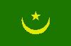
 It is bordered by the Atlantic Ocean. Area: 398,000 sq mi (1,030,700 sq km). Population (2002 est.): 2,656,000. Capital: Nouakchott. The Moors (of mixed Arab-Berber and Sudanic descent) constitute the great majority of the population. Languages: Arabic (official), Fulani, Soninke, Wolof (all national). Religion: Islam (official). Currency: ouguiya. Most of Mauritania is made up of low-lying desert that forms the extreme western part of the Sahara. Only a tiny fraction of its land is arable, but almost two-fifths is suitable for grazing, and the herding of goats, sheep, and camels occupies a significant portion of the largely nomadic population. Ocean fishing and iron ore production are major sources of revenue. Mauritania is a republic with two legislative houses; its head of state and government is the president, who is assisted by the prime minister. Inhabited in ancient times by Sanhaja Berbers, in the 11th–12th centuries it was the centre of the Berber Almoravid dynasty, which imposed Islam on many of the neighbouring peoples. Arab tribes arrived in the 15th century and formed several powerful confederations: Trarza and Brakna, which dominated the Sénégal River region; Kunta in the east; and Rigaibat in the north. The Portuguese arrived in the 15th century. France gained control of the coastal region in the Senegal treaty of 1817, and in 1903 a formal French protectorate was extended over the territory. In 1904 it was added to French West Africa, and in 1920 it became a colony. In 1960 Mauritania achieved independence and left the French Community. The country's first president, Moktar Ould Daddah, was ousted in a coup in 1978, and a military government was established. In 1980 a civilian government was set up, and in 1991 a new constitution was adopted. During the 1990s relations between the government and opposition groups deteriorated, although there was some success in liberalizing the economy.
* * *
▪ 2009Area:1,030,700 sq km (398,000 sq mi)Population(2008 est.): 3,204,000Capital:NouakchottChief of state:President Sidi Mohamed Ould Cheikh Abdallahi and, from August 6, Chairman of the High Council of State Mohamed Ould Abdel AzizHead of government:Prime Ministers Zeine Ould Zeidane, Yahya Ould Ahmed El Waghef from May 6 to August 6, and, from August 14, Moulaye Ould Mohamed LaghdafMauritania's brief experiment with democracy ended on Aug. 6, 2008, when a military coup toppled Pres. Sidi Mohamed Ould Cheikh Abdallahi, the country's first democratically elected president since independence in 1960. The coup, led by Gen. Mohamed Ould Abdel Aziz, followed an unpopular cabinet reshuffle in May and a July no-confidence vote passed by the National Assembly, which President Abdallahi then threatened to dissolve. Demonstrators backing the coup clashed with supporters of the ousted government, but calm returned to the capital within a few days. New elections were promised, but no date was specified. Ignoring international condemnation of the coup, the freezing of aid from major donors, and suspension from the African Union, General Abdel Aziz formed a new government during August.An Algeria-based group, al-Qaeda in the Islamic Maghreb (AQIM), claimed responsibility for the deaths of four French tourists in the Mauritanian town of Aleg in December 2007. Five of AQIM's alleged members were arrested in Guinea-Bissau on Jan. 11, 2008. Subsequent security fears prompted the cancellation of the Dakar Rally. On February 1, terrorists attacked the Israeli embassy in Nouakchott, injuring five people. Though seven suspects were arrested a week later, they were released for lack of evidence on February 19. Twelve Mauritanian soldiers were ambushed in the north by AQIM on September 15; their bodies were found four days later.The UN-organized repatriation of 24,000 Mauritanian refugees who had been living in Senegal for nearly 20 years began in January. By July some 4,000 had returned to Mauritania, but the program came to a virtual standstill as the refugees awaited the policy of the new government.Nancy Ellen Lawler▪ 2008Area:1,030,700 sq km (398,000 sq mi)Population(2007 est.): 3,124,000Capital:NouakchottChief of state:Chairmen of the Military Council for Justice and Democracy Ely Ould Mohamed Vall and, from April 19, Sidi Mohamed Ould Cheikh AbdallahiHead of government:Prime Ministers Sidi Mohamed Ould Boubakar and, from April 20, Zeine Ould ZeidaneVoters went to the polls on March 11, 2007, to elect a new president for Mauritania from among 19 candidates, but none of them were members of the military junta that had seized power in 2005 from Pres. Sidi Ahmed Ould Taya. On March 25 Sidi Mohamed Ould Cheikh Abdallahi, who had served in Taya's cabinet, took 53% of the vote in the second round, defeating opposition leader Ahmed Ould Daddah. The balloting marked Mauritania's first truly democratic presidential election since independence in 1960. The African Union indicated its approval by lifting Mauritania's suspension (since the 2005 coup) from that body. On June 8 President Abdallahi announced that he and his cabinet would take a 25% pay cut owing to lower-than-projected oil revenues.On May 21, after months of postponements, the trial began of some 20 members of militant Islamic groups. President Abdallahi stated that he would continue to enforce the junta's policy of cracking down on dissidents who allegedly were linked to al-Qaeda.The delayed rainy season began with a vengeance on August 7, two weeks after Abdallahi had asked the Mauritanians to pray for rain. Within days, devastating flash floods had wiped out thousands of homes in the southeastern community of Tintane. Heavy rains later that month inundated villages in the southern regions of Gorgol and Assaba.On August 9 the parliament voted to impose prison terms of up to 10 years on those practicing, praising, or promoting slavery. Although such labour had been banned since 1981, slave owners had not faced criminal penalties for continuing the practice.Nancy Ellen Lawler▪ 2007Area:1,030,700 sq km (398,000 sq mi)Population(2006 est.): 3,158,000Capital:NouakchottChief of state:Chairman of the Military Council for Justice and Democracy Ely Ould Mohamed VallHead of government:Prime Minister Sidi Mohamed Ould BoubakarMauritanian leader Ely Ould Mohamed Vall, who came to power in a coup in 2005, made his first official tour of the country in May 2006. Vall reiterated his determination to restore democracy and to step down after elections in 2007. Promising that he would not stand as a candidate, Vall assured the crowds that a “yes” vote in the referendum on his proposed constitutional changes would eliminate future coups and civil wars. Results of the referendum released on June 26 showed a 96% vote in favour of the reforms, which included limiting presidents to two consecutive terms of five rather than six years and setting a presidential maximum age of 75. Voter turnout was about 76%. Following elections late in the year, the Coalition of Forces of Democratic Change captured 41 of the 95 seats in the National Assembly; independents won 39 seats.West African migrants attempting to enter Europe through the Canary Islands by using overcrowded, unseaworthy vessels had led to more than 1,000 deaths since November 2005. At least 45 died in two shipwrecks on the night of March 4. Spain and Mauritania signed an agreement on March 17 to tighten borders and to beef up offshore patrols.Mauritania began harvesting its offshore oil resources in late February, despite a dispute over the division of prospective revenues between the state and Australian-owned Woodside Petroleum. On June 1 the World Bank approved a $10 million credit for improvements in the health and nutrition sector, and three weeks later the IMF canceled Mauritania's $830 million debt.Nancy Ellen Lawler▪ 2006Area:1,030,700 sq km (398,000 sq mi)Population(2005 est.): 3,069,000Capital:NouakchottChief of state:President Col. Maaouya Ould SidʾAhmed Taya and, from August 3, Chairman of the Military Council for Justice and Democracy Ely Ould Mohamed VallHead of government:Prime Ministers Sghair Ould MʾBarek and, from August 7, Sidi Mohamed Ould BoubakarTaking advantage of Pres. Maaouya Ould SidʾAhmed Taya's absence at the funeral of Saudi Arabian King Fahd (Fahd ) (see Obituaries), dissident Mauritanian army officers launched a successful coup on Aug. 3, 2005. A former close ally of Taya, Col. Ely Ould Mohamed Vall, emerged as the leader of the Military Council for Justice and Democracy. All but one of its 17 members were colonels. News of the bloodless coup was greeted by huge celebrations in the streets. Vall sought to reassure the international community that democracy would be swiftly restored, with a referendum on a new constitution to be held within a year and legislative elections to follow immediately. The African Union, the European Union, and the U.S. initially condemned the coup, but after talks with Vall and members of the Council, they expressed guarded support for the new regime.On September 2 Vall proclaimed a general amnesty for political prisoners. Many were freed immediately. Among them were scores of men arrested earlier in the year on suspicion of being Islamic militants, as well as two of the four army officers sentenced to life imprisonment on February 3 for having participated in the failed June 2003 coup. On September 13 thousands of opposition supporters mobbed the airport to welcome 30 former dissidents back from exile.Nancy Ellen Lawler▪ 2005Area:1,030,700 sq km (398,000 sq mi)Population(2004 est.): 2,774,000Capital:NouakchottChief of state:President Col. Maaouya Ould SidʾAhmed TayaHead of government:Prime Minister Sghair Ould MʾBarekOn Aug. 10, 2004, the government of Mauritania claimed that it had prevented an army coup aimed at assassinating Pres. Maaouya Ould Taya a few days before his official visit to France. At least 20–30 soldiers, many of them high-ranking officers in the elite National Guard, were arrested. Defense Minister Baba Ould Sidi accused the plotters of having close links with the failed coup of June 2003, for which 123 men remained in detention. There was apparently considerable discontent in the army over issues ranging from low pay to the government's maintenance of diplomatic relations with Israel. On August 27 Chief of Police Sidi Ould Riha charged that the governments of Burkina Faso and Libya had supported the coup and had allowed rebel commando units to live and train on their territory.Mauritania, among the world's poorest nations, saw prices rise sharply and the value of its currency plummet by 30% beginning in May. On July 26, as part of a purge affecting those responsible for economic policy, Pres. Taya reshuffled his cabinet and fired nine senior members, as well as the governor of the central bank. On August 3 the World Bank announced a grant of $15 million to Mauritania to modernize its education sector. An Australian corporation announced on May 31 that it would invest $600 million to develop the Chinguetti offshore oil field, thought to be Mauritania's most promising petroleum site.In August the government appealed to the global community for planes and insecticides to combat a locust plague; massive infestations of the pests were devastating many of Mauritania's fields and pastures, and a major food crisis seemed inevitable.Nancy Ellen Lawler▪ 2004Area:1,030,700 sq km (398,000 sq mi)Population(2003 est.): 2,696,000Capital:NouakchottChief of state:President Col. Maaouya Ould SidʾAhmed TayaHead of government:Prime Ministers Cheikh El Avia Ould Mohamed Khouna and, from July 6, Sghair Ould MʾBarekAs a result of the U.S.-led invasion of Iraq, Mauritanian Pres. Maaouya Ould SidʾAhmed Taya in May 2003 ordered a crackdown on Islamic militants, opposition party members, and other critics of his regime. Dozens were arrested, and the Arabic-language newspaper Erraya was charged with subversion and shut down. On June 8 rebels led by former army colonel Saleh Ould Hannena attacked the presidential palace with tanks and machine guns, drove Taya into hiding, shut down television and radio broadcasts for 24 hours, and released all prisoners from the capital's jail. The coup failed when the bulk of the army remained loyal to the government, but in two days of intense fighting at least 30 people were killed. Among them was the army chief of staff, Mohamed Lemine Ould NʾDeyane, one of the president's closest advisers. The reasons behind the coup remained unclear. On August 6 the 90 soldiers who had been taken into custody following the coup were released, and on August 22 the clerics and political opponents jailed in May were freed. In the November 7 presidential election, Taya was returned to power with 67% of the vote.Although torrential rains finally unleashed in August, hundreds of thousands of people were still suffering from the 2002 drought. On February 18 OPEC contributed $300,000 to the emergency food operation organized by the World Food Programme. In early July the World Bank approved $39 million in grants and credits to finance improvements in mining operations and to fight the spread of HIV/AIDS. On a more positive note, Mauritanian director Abderrahmane Sissako's film Heremakono won the top prize at Fespaco, the pan-African film and television festival.Nancy Ellen Lawler▪ 2003Area:1,030,700 sq km (398,000 sq mi)Population(2002 est.): 2,656,000Capital:NouakchottChief of state:President Col. Maaouya Ould Sidi Ahmad TayaHead of government:Prime Minister Cheikh El Afia Ould Mohamed KhounaOn Jan. 3, 2002, the government banned the opposition Action for Change (AC) party, claiming that it advocated racism and violence. The AC, which promoted the rights of black Mauritanians and descendents of slaves, would, however, be permitted to retain the four seats in the National Assembly that it had won in the October 2001 elections.Heavy rains and extremely cold weather in January killed at least 25 people and an estimated 80,000 head of livestock. On January 28 the United Nations World Food Programme (WFP) put an emergency food-distribution plan into action to help approximately 5,500 families affected in the northwest of the country. Drought, which had plagued the region since 2001, returned after the adverse weather, and on April 3 the WFP appealed for $7.5 million in addition to the $22 million already earmarked for famine relief. International donors were slow to respond, and the WFP announced on June 4 that purchase and distribution of staple foodstuffs to a quarter of a million people had been delayed owing to lack of funding. The government reported that by September the lack of rainfall had seriously affected 9 of the country's 13 regions. On September 17 the Christian charity World Vision revealed plans to open 181 feeding centres in the Tagant and Assaba regions, calling the situation one of near famine.The Paris Club of creditor nations accepted Mauritania's pledge to initiate further economic reforms and on July 8 announced it would reduce its debt by $188 million. On July 17 the African Development Bank approved further debt relief in the amount of $72.8 million.Nancy Ellen Lawler▪ 2002Area:1,030,700 sq km (398,000 sq mi)Population(2001 est.): 2,591,000Capital:NouakchottChief of state:President Col. Maaouya Ould Sidi Ahmad TayaHead of government:Prime Minister Cheikh El Afia Ould Mohamed KhounaOn April 8, 2001, police arrested Mohamed Lemine ChʿBih Ould Cheikh Melainine, leader of the Popular Front. Despite widespread criticism by opposition parties and international human rights organizations, he was brought to trial in Nouakchott on May 9 and charged with criminal conspiracy. Defense lawyers resigned in protest after the proceedings were abruptly moved to Aioun, near the Malian border, 800 km (500 mi) south of the capital. Though critics condemned the trial as nothing more than a show, Melainine was sentenced on June 14 to five years' imprisonment.On August 4 an agreement on fishing rights was renewed between the government and the European Union. Despite the fears of environmentalists that increased fishing would further reduce the already sharply depleted stocks, the revised protocol nevertheless allowed for an increased number of European vessels to fish the area around the island of Agadir off the northern Mauritanian coast.King Muhammad VI of Morocco began a three-day state visit to Mauritania on September 10. Ties had been strained between the two countries since 1975, when in a dispute over independence for Western Sahara, claimed by Morocco, Mauritania had actively supported the Western Saharan Polisario Front; Mauritania later shifted its stance to one of neutrality, and the king's visit was seen as an indication of the importance that both countries attached to improving relations.In the legislative and municipal elections held on October 19 and 26, the ruling Democratic and Social Republican Party garnered 51% of the vote and captured 64 of the 81 seats in the National Assembly.Nancy Ellen Lawler▪ 2001Area:1,030,700 sq km (398,000 sq mi)Population(2000 est.): 2,668,000Capital:NouakchottChief of state:President Col. Maaouya Ould Sidi Ahmad TayaHead of government:Prime Minister Cheikh El Afia Ould Mohamed KhounaMauritania's staggering international debt received some promises of reduction during 2000 when it qualified for the Heavily Indebted Poor Countries, a project of the International Monetary Fund and the World Bank. The G-7 group of wealthy nations announced on July 21 that Mauritania, along with six other sub-Saharan African countries, was eligible for a share of a new $15 billion debt-reduction program. The government took steps toward developing its mineral resources when it granted two exploration permits to enable a Canadian mining company to prospect for gold and strategic metals in the Akchar region.The offshore fishing industry continued to struggle with the problem of foreign competitors within its territorial waters. Fishing accounted for 65% of export earnings and constituted 40% of the national budget. A complete ban on commercial fishing during the breeding season of September and October was announced on August 31. The results, however, proved disappointing, as the area had been overfished for many years. Pres. Abdoulaye Wade of Senegal paid a state visit to Mauritania in late June. On the agenda was the controversial fossil valley land reclamation project along the Sénégal River, which Mauritania charged would cause the drying up of land on its side of the river. Wade agreed to abandon the project.Nancy Ellen Lawler▪ 2000Area:1,030,700 sq km (398,000 sq mi)Population(1999 est.): 2,582,000Capital:NouakchottChief of state:President Col. Maaouya Ould Sidi Ahmad TayaHead of government:Prime Minister Cheikh El Afia Ould Mohamad KhounaPres. Maaouya Taya's ruling party and its allies took control of all local councils in 1999 after two-stage Mauritanian elections held on January 29 and February 5. Major opposition parties boycotted the poll on the grounds that they had not been consulted on its conduct and organization. In March the government announced that Ahmed Ould Daddah, runner-up in the 1992 presidential election and leader of the opposition Union of Democratic Forces, would stand trial on charges of inciting intolerance and seeking to disrupt public order.Following the arrest in France in July of Capt. Ely Ould Dah on charges of torture, Mauritania expelled some 40 French military advisers and recalled 16 Mauritanian officers currently being trained in France. Economic links with France, Mauritania's most important trading partner, were not disrupted. Violent border incidents over disputed water rights took place in June when Mauritanian villagers clashed with Malian farmers in the southeast. In September an estimated 12,000 people were left homeless as freak floods inundated the Kaedi district. A U.S. bomb-disposal unit spent a week in the north of the country in October surveying land mines still in place from military operations in the Western Sahara in the 1970s. On October 31 Mauritania established ambassadorial-level ties with Israel, an action that outraged a number of Arab League states, particularly Libya.Inflation for the year fell below 5%. The International Monetary Fund approved a three-year, $56.5 million low-interest loan for the country in July, citing significant progress in improving the country's basic economic structure.Nancy Ellen Lawler▪ 1999Area: 1,030,700 sq km (398,000 sq mi)Population (1998 est.): 2,511,000Capital: NouakchottChief of state: President Col. Maaouya Ould Sidi Ahmad TayaHead of government: Prime Ministers Mohamed Lemine Ould Guig and, from November 16, Cheikh Afia Ould Mohamed KhounaThe arrest of three human rights activists for participating in a French television program about slavery in Mauritania sparked protests by the country's lawyers, who went on a 24-hour strike in Nouakchott on Jan. 21, 1998. The Arab Regional Program for Human Rights Activists, based in Cairo, called on Arab governments and international human rights groups to pressure the government to free the three men. In February Morocco's Organization of Human Rights protested the arrest in Mauritania of a fourth person for antislavery activities. Sentences of 13 months each in prison were upheld by the appeals court in Nouakchott on March 24, but Pres. Maaouya Ould Sidi Ahmad Taya immediately pardoned the rights activists.On April 12 clashes between Mauritanian refugees and Senegalese villagers in Kidira district, just south of the frontier, resulted in the death of seven persons, and three more died in additional incidents during the next week. On April 24 the Paris Club of creditor nations placed Mauritania on its list of heavily indebted nations expected to become eligible for special debt relief. President Taya reshuffled his government on July 12. No explanation was given for the dismissal of the ministers for foreign affairs and rural development.The economy was expected to grow by about 5% in 1998, with inflation hovering around 4.7%. Work continued on a new investment code designed to increase private foreign participation in the economy, particularly in the mining and fishery sectors.NANCY ELLEN LAWLER▪ 1998Area: 1,030,700 sq km (398,000 sq mi)Population (1997 est.): 2,411,000Capital: NouakchottChief of state: President Col. Maaouya Ould Sidi Ahmad TayaHead of government: Prime Minister Cheikh Afia Ould Mohamed KhounaRelations between the government and opposition groups deteriorated in 1997. On January 25 leaders of the six main opposition parties, along with many of their supporters, were arrested on charges of conspiracy and detained for several weeks. In March a new opposition coalition, formed to coordinate strategy for the presidential elections in December, called for a new electoral code, access to the state-owned media, and the formation of an independent electoral commission. The government refused to consider these demands. In April, despite a ban on demonstrations, several opposition parties marched to protest sharp rises in the cost of living. In July the opposition coalition announced that it would boycott the presidential election and thus virtually ensured the reelection of Pres. Maaouya Ould Sidi Ahmad Taya in December.After mediation by Tunisia, Mauritania and Libya agreed in March to restore full diplomatic relations, which had been broken off in 1995 when Mauritania established ties with Israel. Talks with Senegal were held in June, with both nations seeking to improve cooperation on matters of common concern, including trade and security.On July 14 the International Monetary Fund approved a $20 million loan for Mauritania's structural-reform program, praising the country's efforts over the past five years to liberalize the economy. The economy was expected to grow by 5% in 1997, though prices were also projected to rise by 5%, owing in part to a severe drought that affected much of the nation.NANCY ELLEN LAWLERThis article updates Mauritania, history of (Mauritania).▪ 1997The republic of Mauritania is on the Atlantic coast of West Africa. Area: 1,030,700 sq km (398,000 sq mi). Pop. (1996 est.): 2,333,000. Cap.: Nouakchott. Monetary unit: ouguiya, with (Oct. 11, 1996) a free rate of 138.50 ouguiya to U.S. $1 (218.17 ouguiya = £1 sterling). President in 1996, Col. Maaouya Ould Sidi Ahmad Taya; prime ministers, Sidi Mohamed Ould Boubacar and, from January 2, Cheikh Afia Ould Mohamed Khouna.Cheikh Afia Ould Mohamed Khouna succeeded Sidi Mohamed Ould Boubacar as prime minister of Mauritania on Jan. 2, 1996. Few changes were expected in the four-year-old policy of economic liberalization aimed at making the ouguiya a fully convertible currency. Only three opposition parties put forward candidates for the April 12 elections for the Senate, chosen by an electoral college. The others boycotted the election in protest against the domination of the electoral college by the Democratic and Social Republican Party (PRDS). The PRDS won 17 of the 18 contested seats. In the October legislative elections, the PRDS again scored a lopsided victory.On July 16 Abdoulaye Ould Mohamed Mahoud, the deputy director of state security, confirmed that seven senior police officers and four magistrates were among some 50 persons who had been arrested on charges that they were connected to a network trafficking in illegal drugs.The government sought to strengthen ties, increase cooperation, and improve border security with Mali and Senegal.(NANCY ELLEN LAWLER)This article updates Mauritania, history of (Mauritania).▪ 1996The republic of Mauritania is on the Atlantic coast of West Africa. Area: 1,030,700 sq km (398,000 sq mi). Pop. (1995 est.): 2,274,000. Cap.: Nouakchott. Monetary unit: ouguiya, with (Oct. 6, 1995) a free rate of 132.56 ouguiya to U.S. $1 (209.56 ouguiya = £1 sterling). President in 1995, Col. Maaouya Ould Sidi Ahmad Taya; prime minister, Sidi Mohamed Ould Boubacar.Massive demonstrations erupted in Nouakchott on Jan. 21, 1995, when crowds protested the huge increases in the costs of basic commodities as a result of the imposition of a value-added tax. For three days the capital was virtually shut down as students and unemployed young men burned cars and looted shops. The government accused the opposition of instigating the riots and arrested eight prominent leaders, including Ahmad Ould Daddah of the coalition Union of Democratic Forces-New Era (UFD-EN), and Hamdi Ould Mouknass of the Union for Democracy and Progress (UDP). Although all were released within a few weeks, opposition groups in turn accused the government of mistreating the detainees.In March the Movement of Independent Democrats withdrew from the UFD-EN in March, and aligned itself with Pres. Maaouya Taya's ruling Democratic and Social Republican Party. In July six opposition parties, including the UFD-EN and the UDP, formed a new coalition to achieve a transition to democracy and to press for a new electoral code and an accurate electoral roll. Cracks in the opposition appeared, however, when UFD-EN dissidents, apparently representing black Mauritanians, announced the formation of a new party on August 29.Mauritania's international creditors agreed on June 30 to reschedule the government's public debt. Part of the debt was annulled, and payments on the remainder were to be spread over 23 years. Late rains and a plague of locusts delayed the normal July start of the planting season. As a result, agricultural production was likely to suffer. All offshore fishing in Mauritanian waters, except for tuna, was suspended in September in order to allow sharply diminished stocks to recover. (NANCY ELLEN LAWLER)This updates the article Mauritania, history of (Mauritania).▪ 1995The republic of Mauritania is on the Atlantic coast of West Africa. Area: 1,030,700 sq km (398,000 sq mi). Pop. (1994 est.): 2,069,000. Cap.: Nouakchott. Monetary unit: ouguiya, with (Oct. 7, 1994) a free rate of 123.67 ouguiya to U.S. $1 (196.69 ouguiya = £1 sterling). President in 1994, Col. Maaouya Ould Sidi Ahmad Taya; prime minister, Sidi Mohamed Ould Boubacar.The Interior Ministry reported on Jan. 20, 1994, only eight days before the local government elections were to be held, that the army had arrested dozens of people on charges of printing false voter identification cards. Those detained included members of the majority Democratic and Social Republican Party (PRDS) as well as officials of several opposition parties. Despite the scandal, PRDS candidates overwhelmed the opposition, winning control of 172 of Mauritania's 208 communes. A petition filed by the main opposition party, the Union of Democratic Forces-New Era (UFD-EN), to nullify the elections on grounds of vote fraud was ignored by the government. The opposition was further weakened by a split in the UFD-EN in June, when one faction withdrew to form a new alliance, the Movement of Independent Democrats.On May 18, citing state security, police confiscated copies of the newspaper Le Calame, which had published a damaging report by the International Human Rights Association on the situation in the country. Negotiations over plans to transfer 15,000-20,000 Tuareg refugees to Mali in the near future were conducted in late July.In October the government arrested 60 leaders of Islamic organizations, including former religious affairs minister Abu Bakr Ould Ahmad. They were charged with creating a "climate of fear" among Muslims and undermining national security by indoctrinating children into a new, underground organization. On October 19 the government ordered all militant Mauritanian Islamic organizations to suspend their activities. (NANCY ELLEN LAWLER)This updates the article Mauritania, history of (Mauritania).▪ 1994The republic of Mauritania is on the Atlantic coast of West Africa. Area: 1,030,700 sq km (398,000 sq mi). Pop. (1993 est.): 2,171,000. Cap.: Nouakchott. Monetary unit: ouguiya, with (Oct. 4, 1993) a free rate of 112.98 ouguiya to U.S. $1 (171.17 ouguiya = £1 sterling). President in 1993, Col. Maaouya Ould Sidi Ahmed Taya; prime minister, Sidi Mohamed Ould Boubacar.On May 29, 1993, the National Assembly granted unconditional amnesty to all military and security personnel convicted of violent actions that had resulted in the deaths of several hundred black Mauritanians between April 15, 1990, and April 15, 1991. The following day, police used tear gas to disperse hundreds of angry demonstrators in Nouakchott who were protesting the passage of the bill. Tensions between Moors and black Mauritanians remained high. Hamdi Ould Mouknass, leader of the opposition Union of Democratic Forces-New Era, was arrested on June 24, reportedly two days before a scheduled press conference.Despite the restoration of full diplomatic relations with Senegal and the reopening of the border in 1992, more than 50,000 Mauritanian refugees who had fled to Senegal depended upon aid from international organizations. An additional 8,000 refugees from the conflict were expected to provide for themselves as a result of previous aid programs.The burden of international debt continued to depress the economy. In January, Japan provided 1,480,000,000 yen to restructure and reschedule debts owed to it. The Paris Club reduced Mauritania's debt by 50%.(NANCY ELLEN LAWLER)This updates the article Mauritania, history of (Mauritania).* * *
Introductionofficially Islāmic Republic of Mauritania , Arabic Mūrītānīyā , or al-Jumhūrīyah al-Islāmīyah al-Mūrītānīyah , French Mauritanie , or République Islamique de MauritanieMauritania, flag of state in northwestern Africa. It has the shape of an indented rectangle measuring about 930 miles (1,500 kilometres) from north to south and about 680 miles from east to west. It is bordered to the northwest by the Western Sahara (formerly Spanish Sahara), to the northeast by Algeria, to the east and southeast by Mali, and to the southwest by Senegal. Its Atlantic Ocean coastline, to the west, extends for 435 miles from the delta of the Sénégal River northward to the Cap Blanc Peninsula. The capital is Nouakchott.Mauritania forms a geographic link between the North African Maghrib (a region that also includes Morocco, Algeria, and Tunisia) and the Senegal region of western Africa. Culturally it forms a transitional zone between the Arab-Berber region of North Africa and the region to the south of the tropic of Cancer known as the Sudan (a name derived from the Arabic bilād as-sūdān, “land of the blacks”). Much of Mauritania forms part of the western Sahara, and a large proportion of the population is nomadic. The country's mineral wealth includes large reserves of iron ore, copper, and gypsum, which are now all being exploited.Mauritania, formerly French administered, became independent on Nov. 28, 1960. By the terms of the constitution, Islām is the official state religion, but the republic guarantees freedom of conscience and religious liberty to all. Arabic (Arabic language) is the national language, and the official languages are Arabic and French.The landRelief, drainage, and soilsBoth land relief and drainage are influenced by the aridity that characterizes the greater part of the country. The impression of immensity given by the landscape is reinforced by its flatness; the coastal plains are lower than 150 feet (45 metres), while the higher plains of the interior vary from 600 to 750 feet. The interior plains form a plateau of which the culminating heights, occurring at different levels, form many tablelands joined to one another by very long, gentle slopes of about 2°. The topography is relieved by vestiges of cliffs (generally cuestas); by sloping plains that terminate at one end of the slope with a steep cliff or faulted scarp, which may reach heights of 900 feet; or by inselbergs (steep-sided residual hills), of which the highest is Mount Ijill at 3,002 feet (915 metres), an enormous block of hematite.Structurally, Mauritania may be divided into three principal zones. The first of these, located in the north and northwest, consists of underlying Precambrian rock (about 2.7 billion years old), which emerges to form not only the backbone of northern Mauritania's Rigaibāt ridge region but also the Akjoujt rock series that forms a vast peneplain (a land surface worn down by erosion to a nearly flat plain) studded with inselbergs. The second zone is located partly in the extreme north but mostly in the centre and east. In the north it consists of primary sandstone, which covers the Tindouf Syncline (a fold in the rocks in which the strata dip inward from both sides toward the axis); in the centre is the vast synclinal basin of Taoudeni, bounded by the Adrar, Tagant, and ʾAçâba plateaus. The basin is scarcely indented to the south by the Hodh Depression, with the Affollé Anticline (a fold in which the rock strata incline downward on both sides from a central axis) lying in its centre. The third zone is formed by the Senegalese-Mauritanian sedimentary basin, which includes coastal Mauritania and the lower Sénégal River valley of the southwest.The Mauritanian landscape in general, as a result of the arid phases it underwent during the Quaternary period (i.e., within the past 1.6 million years), presents three different aspects; these are represented by skeletal soils, regs (desert surfaces consisting of small, rounded, tightly packed pebbles), and dunes.Skeletal soils are formed where outcrops of the underlying rock have been slightly weathered or where they have been covered with a patina or chalky crust. To these may be added the saline soils of the salt flats, formed from the caking of gypsum or of salt derived from the evaporation of former lakes. The regs form plains often of great extent, carpeted with pebbles and boulders. The dunes cover about 50 percent of the total area of the country. They are stretched out, often for several dozen miles, in long ridges known as ʾalâb, which are sometimes 300 feet high; they frequently overlap with one another, forming a network of domes and basins.It is only to the south of the 10-inch isohyet (an imaginary line connecting points with equal rainfall) that the sands bear a brown type of soil. This soil is characteristic of the steppe (treeless plains) and contains 2 percent humus. It is also only in the extreme southern part of the country that the iron-bearing lateritic soils of the Sudanic zone begin; in the lowest places occur patches of hydromorphic soils—that is to say, soils that have been altered by waterborne materials.The drainage system is characterized by a lack of pattern. Normal drainage is limited to inland southwestern Mauritania, where tributaries of the Sénégal River, which forms the frontier between Mauritania and Senegal, flow southward and are subject to ephemeral flooding in summer. In the greater part of the country, however, the plateaus are cut into by wadis (dry riverbeds), where the rare floods that occur dissipate their waters into a few permanent drainage basins called guelt (singular guelta). In the wastes of the north and the east, rainfall is so rare and slight that there is practically no runoff.ClimateThe climate owes its aridity to the northeastern trade winds (trade wind), which blow constantly in the north and throughout most of the year in the rest of the country; the drying effect produced by these winds is increased by the harmattan, or east wind. With the exception of the few winter rains that occur as a result of climatic disturbances originating in the mid-latitude regions, precipitation essentially results from the rain-bearing southwesterly winds, which progressively extend throughout the southern half of the country at the height of the summer. The duration of the rainy season, as well as the total annual amount of rainfall, diminishes progressively from south to north. Thus, Sélibaby in the extreme south receives about 25 inches (635 millimetres) between June and October; Kiffa, farther north, receives 14 inches between mid-June and mid-October; Tidjikdja receives seven inches between July and September; Atar receives seven inches between mid-July and September; and Nouadhibou receives between one and two inches, usually between September and November. Because of opposition between the wet southwesterlies and the harmattan, rains often take the form of stormy showers or squalls.The strength of the sun and the lack of haze in these latitudes result in high temperatures. In the summer months afternoon temperatures exceed 100° F (38° C) at most stations, and daily highs of 115° F (46° C) are not uncommon in the interior. The average temperature in the coldest month at most stations is in the region of 68° F (20° C), while the average temperature during the hottest month rises to about 75° F (24° C) at Nouakchott in September, to about 79° F (26° C) at Kiffa in May, to 81° F (27° C) at Atar in July, and to 84° F (29° C) at Néma in May.Plant and animal lifeVegetation zones depend upon the degree of aridity, which increases from south to north. The Sudanic (Sudan) savanna, studded with baobab trees and palmyra palm trees, gradually gives way in the extreme south to a discontinuous belt of vegetation known as the Sahel (an Arabic word meaning riverbank, or shore, which is also used to designate the southern Sahara borderlands). In the Sahel, trees are rare and the vegetation consists principally of acacias, euphorbia bushes (plants of the spurge family that have a milky juice and flowers with no petals or sepals), big tufts of morkba (Panicum turgidum, a type of millet), or fields of cram-cram, or Indian sandbur (Cenchrus biflorus, a prickly grass). Between the six-inch and four-inch isohyets the steppe rapidly disappears, giving way to desert. Vegetation is restricted to such places as the dry beds of wadis, beneath which water continues to flow, or to oases.In the savanna, big antelope are hunted by lions, and, in the hilly Afollé region of southern Mauritania, herds of elephants are found. The steppe is frequented by gazelles, ostriches, warthogs, panthers, hyenas, and lynx; crocodiles are found in the guelt. Only addax antelope venture out into the waterless desert. Animal populations have been much reduced by hunting, obliging the authorities to introduce measures for conservation.Settlement patternsThe Sahara region to the north, where habitation is generally limited to oases, stands in contrast to the Sahelian steppelands to the south, where regular rainfall permits extensive stock raising and some agriculture. While transition occurs between one zone and another, a convenient line of demarcation is represented by the four-inch isohyet.The heartland of Mauritania consists of the vast Adrar and Tagant plateaus, known as the Trab el-Hajra (Arabic: “Country of Stone”). There, at the foot of cliffs, are found several oases, among which some—such as Chinguetti, Ouadane, Tîchît, Tidjikdja, and Atar—were the sites of well-known cities in the Middle Ages. To the north and the west extend the vast desert peneplains. The exploitation of the Zouîrât mines and the development of Nouadhibou have transformed this once-abandoned region into the focus of Mauritania's economic life.Coastal southwestern Mauritania (under colonial rule, the Trarza cercle) is covered with regularly aligned dunes and is important for stock raising; Arab-Berber (Moorish) culture is represented by important marabout families.Inland, southwestern Mauritania is inhabited by Moors and Fulani (Peul), who engage in both livestock raising and agriculture. In the extreme south, large villages are surrounded by fields of millet, constituting the first sign of the Sudanese landscape.In the southeast the vast Hodh Basin, with its dunes, sandstone plateaus, and immense regs, is a major livestock-raising region, the economy of which has many links with neighbouring Mali.Mauritania is a country suited for nomadic life. Livestock supplies the nomads with milk and meat, while transport is provided by riding camels and pack camels and, in the south, by pack oxen and donkeys as well. The women dye sheep's wool, with which they then braid long brown bands that are sewn together to make tents; they also tan goats' skins to make guerbas (waterskins). Movement is governed by the search for water and pasturage. In the Sahara nomadic movements are irregular because of the extreme variability of rains; in the Sahel, however, regular seasonal movement occurs—to the south in the dry season and back to the north in the wet season. Sizes of nomadic encampments also vary from south to north. In the coastal southwest, agglomerations of up to 300 tents may be found, whereas in northern Mauritania only groups of a few tents are to be seen.For a variety of reasons—including changes in agricultural patterns as well as in political and commercial relations—the traditional nomadic way of life has been declining. Dams to conserve floodwaters have been built in the wadis, and palm tree culture has been considerably extended. The cumulative result of these developments has been that the nomads now tend to remain longer in the south near their millet fields and palm groves—becoming, in effect, seminomads.Since the 1960s a movement toward settlement has been evident, largely because of growing dissatisfaction with the harsh conditions of nomadic life; this movement, however, has been restricted by the constant lack of water. Only in the extreme south—on the banks of the Sénégal River (in Mauritania the region called the Chemama)—is a normal, settled agricultural life possible. A series of droughts halted cultivation in the Sahel in the 1970s, and livestock raising was seriously constrained, affecting the livelihood of nomads and sedentary peoples alike.The exploitation of the iron ore reserves of Mount Ijill, as well as the achievement of independence, have transformed the urban geography of Mauritania. The ancient cities that lived by caravan traffic—e.g., Tîchît, Chinguetti, Ouadane, and Oualâta—and traded with Casablanca and, above all, with Dakar have grown idle beneath their palm trees. Only Tidjikdja and Atar have maintained a certain activity. Kaédi, on the Sénégal River, has expanded and is still growing. Three new towns have been built: Nouakchott, the capital; Fdérik (formerly Fort-Gouraud); and Nouadhibou (formerly Port-Étienne).Nouakchott was founded in 1958. Formerly, Mauritania shared a capital, Saint-Louis, in Senegal, with the other members of the French West African Federation. Nouakchott is located near the sea and provides access to the Sahara and Sahel regions alike. In addition to being the seat of government and administration, Nouakchott is a growing commercial centre and has a printing works, a hospital, and numerous schools. Its water supply is provided by a plant that desalinizes seawater.Fdérik is an administrative centre situated about 15 miles from the mining town of Zouîrât. The port of Nouadhibou, which was long stagnant, owes its more recent expansion both to expanding iron ore exports and to the establishment of a fishing complex there. A few miles to the south lies Cansado, a residential suburb.The people (Mauritania)Ethnic and linguistic groupsThe Moors (Moor) constitute more than two-thirds of the population; about half of them are white, or bīdān, Moors of Arab and Berber descent, and about half are black Moors, of Sudanic origin. Moorish society historically was divided into a hierarchy of castes. At the head of the socioeconomic structure were the noble castes, composed of ʿarabs, or warriors, and Murābit (marabouts), or priests and scholars of the Qurʾān. The warriors were usually Arab, and the marabouts were usually Berber. The mass of the bīdān population were vassals who received protection from the warriors or marabouts in return for tribute. There were two artisan classes—the blacksmiths and the griots (who were at once musicians and genealogists). Servant classes were formed of black Moors and were subdivided into ʿabid, or slaves, and hartani, or freedmen. Among the ethnic and racial groups, blacks became the better educated and held most technical, professional, and diplomatic posts at the time of independence. Members of this “servant” caste, which developed as the bureaucratic class, became increasingly aware of their rights as citizens. slavery was abolished by the French before independence and was officially abolished again on July 5, 1980, but subsequent reports claimed that the practice had continued. In 2007 the country's legislature passed a bill that made slavery a criminal offense.The Moors speak Ḥassānīyah, a dialect that draws most of its grammar from Arabic and uses a vocabulary of both Arabic and Berber words. Most of the members of the aristocratic castes also know literary Arabic.The remaining population, generally referred to as kewrin, consists of Tukulor (Toucouleur), who live in the Sénégal River valley; Fulani, who are dispersed throughout the south; Soninke (Sarakole), who inhabit the extreme south; and Wolof (Oulof), who live in the vicinity of Rosso in coastal southwestern Mauritania. The Tukulor and the Fulani speak Fula, and the other ethnic groups have retained their respective languages.Of Mauritania's total population an estimated one-fourth are nomads, and about one-third live in and around urban centres. Because of the country's large desert area, the average density is the lowest in western Africa. Three-fourths of Mauritanians live in the Sénégal River valley. Life expectancies stand at 44 and 47 years respectively for men and women.Most of the non-Africans in Mauritania are French nationals engaged in technical assistance, commerce, and mining; Spaniards represent the second largest foreign community.Religious groupsAbout 99 percent of all Mauritanians are Muslim. Most Moors belong to the Qādirīyah order. The Tukulor and some of the Tagant tribes belong to the Tijānīyah order. Many tariqas (mystical sects) flow from these orders.The economyIn the Sahel region of Mauritania a traditional subsistence economy is maintained, composed of livestock raising, agriculture, crafts, and petty trading. In the Sahara region, however, a modern economy is developing, based on the exploitation of iron-ore and copper resources and of the ichthyologically-rich continental shelf; the modern economy receives much needed capital investment and technical assistance from abroad. More than three-quarters of the Mauritanian population still lives by traditional activities, among which livestock raising is the most important. In numbers, goats and sheep are the most important livestock, followed by cattle, camels, donkeys, and horses. Cattle are raised primarily in the southern region, whereas goats and sheep are dispersed as far north as the limits of the Sahara. Camels are raised mostly in the north and the centre, especially in the Adrar region. The growth of the Mauritanian economy slowed in the 1980s after a lengthy period of rapid expansion in the 1960s and '70s. Agriculture and fishing account for almost one-third of the gross national product, with the industrial sector, including mining, contributing about one-quarter, public administration about 15 percent, and the remaining sectors about 30 percent.The state imposes indirect taxes on imports, a turnover tax on exports and mining, a service tax, and taxes on cattle, vehicles, wages and salaries, and profits from industrial and commercial concerns.Mauritania's budget, usually in deficit, was nominally balanced in the late 1980s. In the mid-1980s, principal and interest on a relatively large foreign indebtedness was rescheduled, but indebtedness remains a significant problem. Foreign aid, both bilateral (from France, Japan, China, the United States, and the Arab states) and by multilateral agencies (such as the African Development Bank, International Monetary Fund, International Bank for Reconstruction and Development, and the European Economic Community), is primarily targeted to assist in project development but is also used for budgetary and food support.Agriculture and fishingAgriculture is necessarily dependent upon rainfall. Where the rainfall exceeds 17 inches a year, millet (fonio) and dates are the principal crops, supplemented by sorghum, beans, yams, corn (maize), and cotton. Seasonal agriculture is practiced on the easily flooded riverbanks and in the wadis of the Sahelian zone, upstream from the dams. There, too, millet, sorghum, beans, rice, and watermelons are grown. Irrigated agriculture is practiced in areas supplied by water-control projects and at oases, where well water is available; corn, barley, and some millet and vegetables are grown. The output of gum arabic is less than it was in former years. Agricultural production in Mauritania has continued to decline because of drought. Crop production fell by approximately two-thirds in the period from 1970 to 1980. From the late 1970s Mauritania was unable to produce more than half of its total food requirements.In agriculture the aim of successive Mauritanian governments has been to increase the amount of irrigated land in the Sénégal River valley and, above all, to increase the production of rice, of which Mauritania is still obliged to import large quantities, to plant fresh palm trees to replace those destroyed by the cochineal insect, to drill fresh wells, to improve the quality of dates, and to encourage the cultivation of vegetables.Rich fishing grounds lie off Mauritania's Lévrier Bay. Mauritania stopped issuing fishing licenses in 1979, however, and in 1980 formed joint companies with Portugal, Iraq, South Korea, Romania, and the Soviet Union. In 1987, fisheries agreements were signed with the European Communities. At Nouadhibou fish are canned, frozen, or processed as fish flour. Several tons each year are dried and exported to other African countries.MiningA rail link connects the mining town of Zouîrât with the port of Nouadhibou (Nouâdhibou), the only deepwater roadstead on the Saharan coastline, accommodating ships of up to 150,000 tons. Iron exploitation was organized and begun in 1963 by Miferma (of which 56 percent of the financing was by French groups and the remainder by British, West German, and Italian groups and by the Mauritanian government). The company was nationalized in 1974 and was renamed Cominor (Complexe Minier du Nord). The iron ore deposits of Mount Ijill have nearly been exhausted, and exploitation of reserves at Guelbs began in 1984. Iron exports fell from a peak of 12 million tons in 1974 to an annual average of nine million tons in the 1980s.The copper deposits of Akjoujt are extensive, with a copper content of more than 2 percent. Exploitation was begun in 1969 by Somima (Société Minière de Mauritanie), of which 54 percent of the shares were held by British and U.S. interests, 25 percent by the Mauritanian government, and the remainder by French interests. Somima was nationalized in 1975, but operations were suspended in 1978. Reactivation of the mine remains a constant preoccupation, as does the extraction of gold from the copper ore. Processed copper had been exported along a highway to the wharf at Nouakchott. There are substantial gypsum deposits near Nouakchott; most of the annual production is exported to Senegal. Other mineral resources are minor, and salt output has declined. Reserves of ilmenite (the principal ore of titanium) have been located, and phosphate deposits have been identified near Bofal in the south. Oil prospecting has so far yielded no results.Finance and tradeThe national Banque Centrale de Mauritanie was established in 1973. In addition there are five commercial banks. There are no securities exchanges in Mauritania, and the government controls all insurance business.Foreign trade is difficult to estimate because, while imports and exports of the modern sector are well known, there are no statistics for the traditional sector. Mauritania is nevertheless known to import from or by way of Senegal quantities of millet, tea, rice, sugar, cotton goods, and hardware, while it exports to Mali and to Senegal cattle, sheep, and goats. Iron ore together with fish and fish products constitute the major exports.TransportationTransport by pack animals—camels in the north, oxen and donkeys in the south—has retained considerable importance in a society in which a subsistence and barter economy prevails, although transport between cities and regions is increasingly by truck. Considerable hazards, however, confront road builders; among these are moving sand dunes, flash floods in the south, and steep cliffs. Only the main road running from Rosso via Nouakchott, Akjoujt, Atar, Fdérik, and Bir Mogreïn to Tindouf, Algeria, is passable throughout the year. The road between Rosso and Nouakchott is surfaced, as is the section between Nouakchott and Akjoujt. The Trans-Mauritania highway, linking Nouakchott, Kaédi, Kiffa, ʿAyoûn el-ʾAtroûs, and Néma, was completed in 1982. The railroad from Zouîrât to Nouadhibou is used only for transporting iron ore. There are international airports at Nouakchott and Nouadhibou, and other cities are linked by regular air services.The irregularity of the flow of the Sénégal River limits its use as a waterway; Kaédi can be reached only by ships drawing about seven feet at the high-water season, normally from August to October. The port facilities at Nouakchott can accommodate 320,000 tons of shipping a year. Nouadhibou, in addition to being an iron ore and fishing port, is also a commercial port.Administration and social conditionsGovernmentThe Mauritanian state had a presidential regime from 1960 until 1978, when a coup d'état installed a military government. A civilian government established in December 1980 was replaced the following April by a largely military administration. A new constitution in 1991 established a multiparty system and a new bicameral legislative structure.The primary task of Mauritania's successive governments has been to transform a community of diverse tribes, hierarchical in social structure and very strongly differentiated, into a nation. Many of the local barriers to cooperation have been overcome, and traditional regional boundaries have been redrawn. There are 12 administrative regions, each directed by a governor, with the capital forming a separate district.Islāmic law and jurisprudence have been in force since February 1980. Qāḍīs (judges of the Sharīʿah, or Islāmic law) in rural and town communities hear cases relating to marriage, divorce, and other personal status issues. Nouakchott is divided into six regional sections where magistrates and judges hear cases in lower courts; there are also labour and military courts, the Court of State Security, and a Supreme Court, which deals with administrative as well as judicial matters.EducationLess than two-fifths of Mauritania's adult population is literate. Schooling is compulsory to age 14, but, in fact, only a small minority of children benefit from it. In addition to primary schools in the urban centres, there are secondary schools, a university with faculties of letters and human sciences and of law and economics, and a research institute for mining and industry in Nouakchott. The capital is also the site of a national library. There are traditional local libraries in some urban centres.Health and welfareModern health facilities are scarce in Mauritania, with only one major hospital in Nouakchott and 25 other regional health centres, of which 15 are maternity clinics. Free medical services are available to the poor. Traditional medicine flourishes. Among other health problems found in tropical areas, tuberculosis and intestinal and eye maladies are widespread. Disability payments for industrial accidents and occupational diseases, family allowances, and old-age pensions are administered by the National Social Insurance Fund.Cultural lifeMoorish society is proud of its Arab and Muslim heritage. Theology, poetry, and music flourish. Goldsmithing is a fine art. Kewri societies have a rich and varied folklore.Mail, telephone, and telegraph services are combined in the main post offices. Fewer than 15,000 telephones are in use, and administrative contact is primarily through radiotelephone. International telephonic communications are run through Paris. The media are owned or controlled by the government. A national radio network broadcasts in the prevailing languages and in French. There are also two Earth satellite stations with telecasts in French and Arabic. A daily, Ach-chaab; a biweekly, Journal Officiel; and a bimonthly, Le Peuple, are published in the two official languages. Movie theatres are found in the main urban centres, and cercles (social, sporting clubs) provide recreational opportunities in Nouakchott, Nouadhibou, and Rosso.Charles Henri Toupet Alfred G. GerteinyHistoryNumerous Stone Age remains have been discovered in northern Mauritania, dating from the Lower Paleolithic (Acheulian) and Neolithic periods. In historical times Mauritania was settled by both sub-Saharan peoples and by the Sanhaja Imazighen (Berbers). The region was the cradle of the Amazigh (Berber) Almoravid (Almoravids) movement, which spread an austere form of Islam to all the neighbouring peoples in the 11th century AD. A caravan route linked Mauritania with Morocco at that time. Arab tribes following this route in the 15th century soon outnumbered the Imazighen, and a mixed Arab-Amazigh, or Moorish, culture was born. These nomadic tribes formed several powerful confederations: the Trarza and Brakna, which dominated the Sénégal River valley; the Kunta in the east; and the Rigaibāt (Regeibat) in the north.European interventionIn 1442 Portuguese mariners rounded Cape Blanc, and in 1448 they founded the fort of Arguin, whence traders shipped gold, gum arabic, and slaves. Later French and English shipping frequented Portendick, and the French settled at Saint-Louis at the mouth of the Sénégal River. In 1858 Colonel Louis Faidherbe (Faidherbe, Louis) waged a military campaign that ended Moorish domination in lower Senegal. After 1898 an Orientalist, Xavier Coppolani, succeeded in rallying all the Moors of the south to French allegiance. His work was completed by Colonel Henri Gouraud, who occupied Tagant in 1907 and Adrar in 1909. The Rigaibāt were not finally subjugated until 1955.Mauritania was constituted a territory of French West Africa in 1920 and later became a French colony; it was at first governed from Saint-Louis in Senegal. In 1946 Mauritania became a French overseas territory and in 1957, after repulsing an attack by Moroccan irregulars on the north, elected a government under Moktar Ould Daddah (Daddah, Moktar Ould), who established the new capital at Nouakchott. In 1958 Mauritania voted to become a member state of the French Community.Hubert Jules Deschamps Ed.IndependenceMauritania's small political elite was divided over whether the country should be oriented more toward Senegal and French-speaking sub-Saharan Africa or toward Arab Muslim Morocco—whose leaders sought to absorb Mauritania. The winning faction, under Sidi el-Moktar N'Diaye and his political successor, Ould Daddah, chose independence—which the country declared on November 28, 1960—with close ties to France. The new state became a member of the United Nations in 1961. Mauritania opted for full participation in the Organization of African Unity and joined the Arab League in 1973.As Mauritania's first postindependence president, Ould Daddah appeared securely established in spite of occasional strikes by miners and demonstrations by students, because his policies seemed attuned to a population that was largely tribal and engaged in agriculture or pastoralism. King Hassan II of Morocco had reversed his policy and recognized Mauritanian independence in 1969 as part of his plan to gain control of what was then Spanish Sahara (now Western Sahara), and Morocco and Mauritania divided that country in 1976. The difficulties of suppressing guerrillas of the Polisario (Polisario Front) Front in Mauritania's portion of Western Sahara contributed to Ould Daddah's downfall, and he was deposed and exiled in a military coup led by the chief of staff, Colonel Mustapha Ould Salek, in July 1978.Ould Salek resigned his position in June 1979, and under his successor, Lieutenant Colonel Mohamed Mahmoud Ould Louly, Mauritania signed a treaty with the Polisario Front in August in an effort to disentangle itself from Western Sahara. This worsened relations with Morocco. Louly was in turn replaced in January 1980 by the prime minister, Lieutenant Colonel Mohamed Khouna Ould Haidalla. In December 1984 Colonel Maaouya Ould Sidi Ahmed Taya took over the presidency and the office of prime minister from Haidalla in a bloodless coup, and Mauritania renewed diplomatic ties with Morocco in 1985, seeking again to resolve the dispute in Western Sahara. Taya was victorious in the country's first multiparty presidential elections in 1992 and was reelected in 1997 and 2003. The elections, however, drew allegations of fraud.In August 2005, while Taya was out of the country, army officers staged a successful coup. Colonel Ely Ould Mohamed Vall, a former close ally of Taya, emerged as the leader of the ruling Military Council for Justice and Democracy. He pledged that democracy would be restored, and in 2006 he presented a referendum on constitutional reforms. Voters overwhelmingly approved the changes, which included limiting presidents to two consecutive terms of five rather than six years. In March 2007 presidential elections were held, and Sidi Ould Cheikh Abdallahi became Mauritania's first democratically elected president.Criticism against President Abdallahi simmered in the months following his election, and tensions escalated in May 2008 when Abdallahi appointed a number of ministers who had held important posts in Taya's government, some of whom had been accused of corruption. The parliament passed a vote of no confidence in July, which was followed by the departure of almost 50 ruling-party members of parliament in early August. On August 6, 2008, President Abdallahi dismissed a number of high-ranking army officials rumoured to have been involved in the parliamentary crisis; in response the military promptly staged a coup and removed him from power.Ed.Additional ReadingIntroductions include Alfred G. Gerteiny, Mauritania (1967); Brian Dean Curran and Joann Schrock, Area Handbook for Mauritania (1972); Charles Toupet and Jean-Robert Pitte, La Mauritanie (1977); and Charles Toupet and Georges Laclavère, Atlas de la République Islamique de Mauritanie (1977). Charles Toupet, La Sédentarisation des nomades en Mauritanie centrale sahélienne (1977), studies geographic and social transformations. The economy is treated in Richard M. Westebbe, The Economy of Mauritania (1971); and Jérôme Pujos, Croissance économique et impulsion extérieure: étude sur l'économie mauritanienne (1964). Alfred G. Gerteiny, Historical Dictionary of Mauritania (1981), is a good reference. Specific periods are examined in C.C. Stewart and E.K. Stewart, Islam and Social Order in Mauritania: A Case Study from the Nineteenth Century (1973); Francis de Chassey, Mauritanie, 1900–1975 (1978, reissued 1984); and Geneviève M. Désiré-Vuillemin, Contribution à l'histoire de la Mauritanie de 1900 à 1934 (1962). Alfred G. Gerteiny* * *
Universalium. 2010.